Giro d'Italia 2025, Stage 8: Giulianova → Castelraimondo
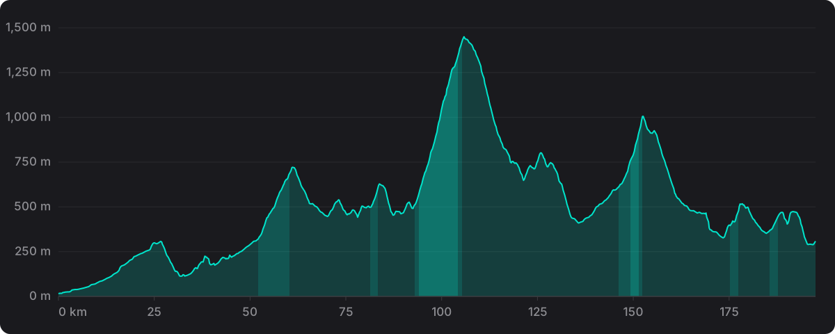
Mountain, 17 May 2025. 197.0 km with 3,792 m of climbing.
- Distance
- 197.0 km
- Climbing
- 3,792 m
- Highest point
- 1,450 m
- Steepest km
- 10.7% at km 99
- Start
- Giulianova 16 m
- Finish
- Castelraimondo 308 m
The wind on the day
Averaged along the route between 12:30 and 18:00 local time: 6 km/h from the north-east, gusting to 21 km/h on average. Rain recorded on parts of the route.
- Average wind
- 6 km/h
- Direction
- North-east 25°
- Average gust
- 21 km/h
- Temperature
- 16°C 8 to 20°C
Historical weather for 17 May 2025, sampled at 48 points along the route and pre-computed before the app shipped. It is not a live forecast and the app makes no weather calls. Weather data by Open-Meteo.com (CC BY 4.0).
Riding it
A mountain stage: 197.0 km, 3,792 m of climbing, 45.2 km of the route above 3% and 7.5 km above 8%.
The high point is 1,450 m at km 106. The steepest kilometre on the profile averages 10.7%, at km 99. It finishes on flat or gently rolling road.
In ProPace the stage runs with this wind along the route, resolved into headwind, tailwind and crosswind at each point, and the app puts your own numbers on it against the pro reference. The reference profile and how the simulation works are set out in How much slower than a pro are you?
Ride Giro d'Italia 2025 stage 8 against a pro in ProPace. Every stage and every feature is free.
