Giro d'Italia 2024, Stage 7: Foligno → Perugia
Individual time trial, 10 May 2024. 40.6 km with 408 m of climbing.
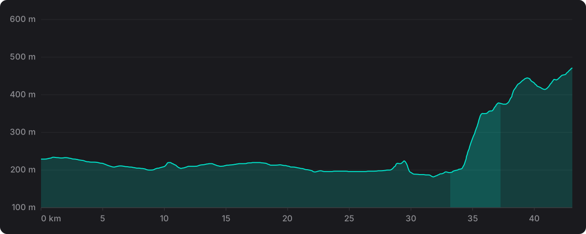
The route stored for this stage does not match the official course exactly: it measures 43.1 km against the official 40.6 km. The distance and climbing above are the official figures; the profile and the gradient figures measured on it come from the stored route, so read them as indicative of the terrain rather than an exact reproduction of the stage.
- Distance
- 40.6 km
- Climbing
- 408 m
- Highest point
- 471 m
- Steepest km
- 9.9% at km 34
- Start
- Foligno 229 m
- Finish
- Perugia 471 m
The wind on the day
Averaged along the route between 13:00 and 17:00 local time: 16 km/h from the north-east, gusting to 36 km/h on average. Dry.
- Average wind
- 16 km/h
- Direction
- North-east 40°
- Average gust
- 36 km/h
- Temperature
- 22°C 21 to 23°C
Historical weather for 10 May 2024, sampled at 12 points along the route and pre-computed before the app shipped. It is not a live forecast and the app makes no weather calls. Weather data by Open-Meteo.com (CC BY 4.0).
Riding it
A individual time trial of 40.6 km with 408 m of climbing, so not a pure power test: 4.0 km of the route rises at more than 3%.
The high point is 471 m at the finish. The steepest kilometre on the profile averages 9.9%, at km 34. It finishes on flat or gently rolling road.
In ProPace the stage runs with this wind along the route, resolved into headwind, tailwind and crosswind at each point, and the app puts your own numbers on it against the pro reference. The reference profile and how the simulation works are set out in How much slower than a pro are you?
Ride Giro d'Italia 2024 stage 7 against a pro in ProPace. Every stage and every feature is free.
